Overview
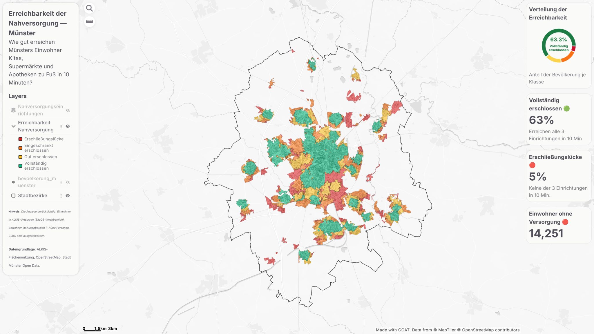
Can you reach a Kita, a supermarket and a pharmacy within a 10-minute walk? That's the standard set by the BBSR Nahversorgungs-Erreichbarkeit methodology for every residential area in Münster, and the question this dashboard answers block by block.
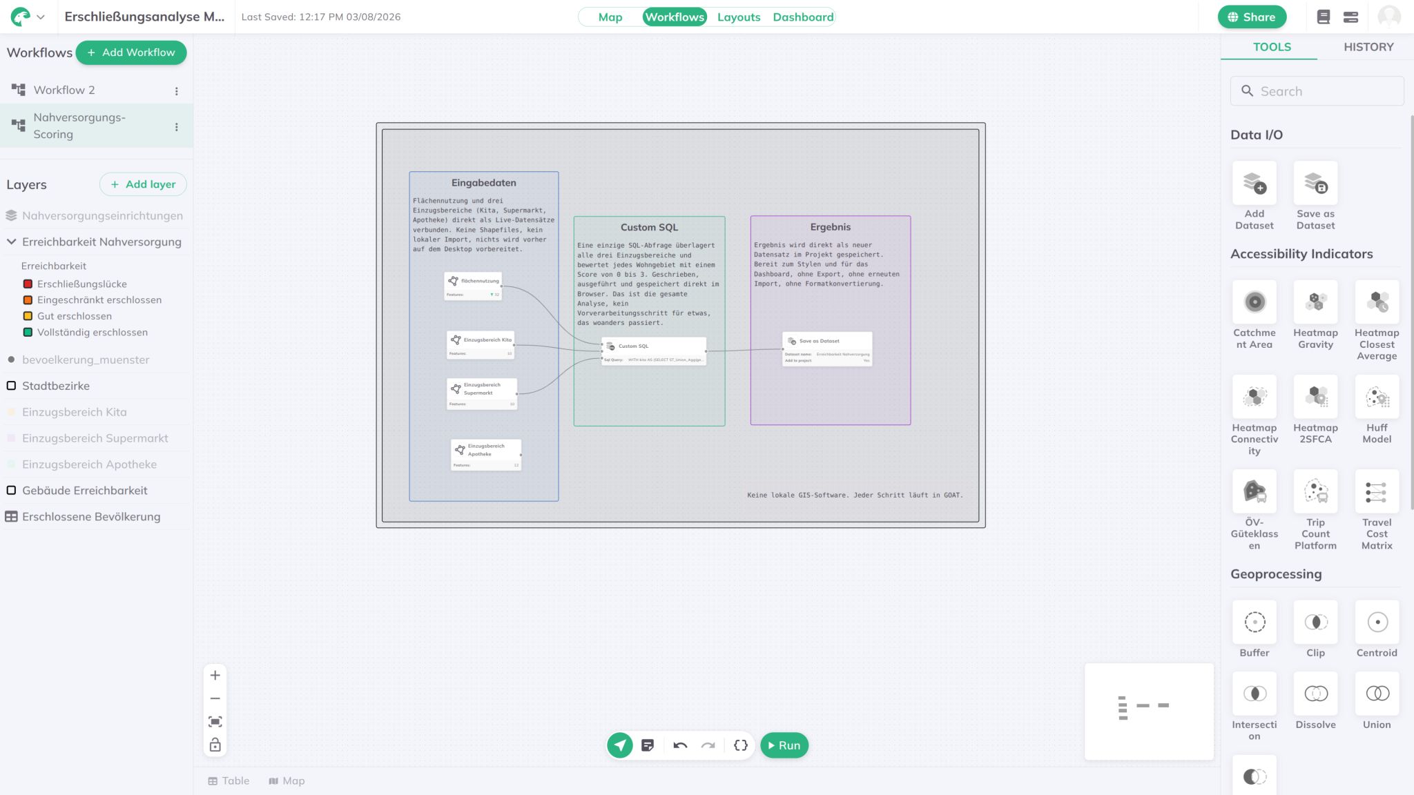
Built entirely in the GOAT Workflow (Plan4Better) — an isochrone tool plus a SQL editor, with no local processing step anywhere in the pipeline. Catchment areas for all three facility types are computed directly in GOAT and combined with a single SQL query to score every residential area from 0 to 3 depending on how many of the three it can reach on foot.
Data sources: ALKIS-Flächennutzung, OpenStreetMap, and Stadt Münster Open Data.
Results
- 63.3% of the population is fully served — all three facility types reachable within 10 minutes
- 5% sit in an actual Erschließungslücke — none of the three reachable on foot
- 14,251 residents without walkable access to basic supply
Methodology
BBSR Nahversorgungs-Erreichbarkeit Standard
Applied the BBSR methodology for basic-supply accessibility: a residential area counts as fully served only when a Kita, a supermarket and a pharmacy are all reachable within a 10-minute walk.
Three Catchment Areas, One Workflow
Computed walking catchments for Kita, Supermarkt and Apotheke directly as live datasets inside GOAT — no shapefiles, no local import, nothing pre-processed on the desktop.
Custom SQL Scoring
A single SQL query overlays all three catchment areas and scores every residential area from 0 to 3 based on how many facility types it can reach — written, run and saved directly in the browser.
Result Saved as a New Dataset
The scored output is saved straight back into the project as a new dataset, ready to style and wire into the dashboard — no export, no re-import, no format conversion.
Dashboard Features
- Four-class accessibility layer: Erschließungslücke, eingeschränkt erschlossen, gut erschlossen, vollständig erschlossen
- Population layer for converting area classes into resident counts
- Stadtbezirke boundaries for orientation across Münster
- Donut chart summarising the population share per accessibility class
Tools & Technologies
- GOAT (Plan4Better) Workflows — catchment areas, custom SQL, dashboard
- ALKIS-Flächennutzung — building and land-use base data
- OpenStreetMap — pedestrian network and facility locations
- Stadt Münster Open Data — supplementary municipal datasets
- BBSR Nahversorgungs-Erreichbarkeit — accessibility methodology
An Honest Caveat
This analysis covers 97.6% of Münster's population. The remaining 2.4%, about 7,030 residents in the Außenbereich, aren't included — the ALKIS-based method only resolves accessibility within built-up residential areas.
Outcome
A fully interactive Nahversorgung accessibility dashboard for Münster, built without a single local processing step — from catchment areas to scoring to final map, everything runs inside GOAT. It gives planners a block-level view of where basic supply access already works, where it's merely adequate, and where a genuine Erschließungslücke leaves residents without a walkable Kita, supermarket or pharmacy.
Workflow
The entire scoring pipeline lives inside a single GOAT workflow — three catchment areas feeding one custom SQL step, saved directly as a new dataset. No local GIS software, no export/import round-trips.